Sept 12-14 –
Southwest Couloir Route
Last summer
Dan and I were planning a trip to Montana’s Granite Peak. Unfortunately an early season snowfall
required us to cancel the outing. Earlier
this year we recruited a few other climbers, my son Dylan, (Super) Dave Pahlas,
and Michael Pelton for the climb and the weather held out!
Dan, Dave, Michael
and I met up with Dylan Friday evening at Steve and Margo’s place in Pocatello. After hugs all around, we were off to Driggs
to catch a few winks at Steve and Margo’s sweet condo. Thanks guys!
The fastest
route to Cooke City, MT requires a trip through Yellowstone National Park. Though it was Saturday morning, we breezed
through the park in a couple of hours and were at the Upper Lulu Pass trail
head hiking toward Lady of the Lake a little after 11AM.
Earlier trip
reports of the Southwest Couloir route showed it to be dry, allowing us lighten
our packs by leaving our ice axes and crampons at home. It was an absolutely gorgeous morning with
bright sunshine and no wind as we made our way along the forested trail. We made quick time up to Lady of the Lake and
had our first extended break at the junction of Zimmer Creak and the Broadwater
River, a little over 3 miles in.
 |
| Michael enjoying the break |
 |
| Dylan |
Following
the break, we took a right and followed the trail down to Sky Top Creek. We then followed Sky Top Creek for another
three miles or so, bypassing the outlet from Lower Aero Lake, before we emerged
into the alpine area of Lone Elk Lake.
At this point we had our first good views of the Granite Peak area, and
they did not disappoint!
 |
| Sky Top Creek |
 |
| Dan entering the alpine zone |
 |
| Headwaters of Sky Top Creek |
 |
| Lone Elk Lake |
From Lone
Elk Lake, we skirted along the left side of Rough Lake and popped over a hill to
enjoy the view of the Sky Top Lakes. We
then boulder hopped our way along the now faint “trail”, before finally
settling on a camp spot on a central Sky Top Lake at 10,500 feet. It was now close to 5PM, where had all the time
gone? It had taken us close to 6 hours to cover the
9 miles and 1700 feet of elevation gain.
Not very fast by normal standards, but we’d actually gained closer to
3000 feet, with 1300 feet of decent during this time.
 |
| Heading to camp |
 |
| Dave and Dylan admiring Granite |
We had a
great view of the left ridge of Granite Peak as we set up camp and cooked
dinner. The alpenglow really made the
mountain shine at sunset.
 |
| Granite from camp |
After a
restless night sleeping and a quick breakfast, we skipped across our Sky Top
lake creek outlet, took a left and headed toward Granite Peak. We initially had easy walking on alpine meadows
interspersed with boulder sections. As
we approached the Sky Top glacial moraine, the meadows gave way to rocks,
boulders and then huge boulders. As we
topped out on the moraine, we had a great view of Granite Peak, though our
route was hidden. From Splattski’s trip
report (
http://www.splattski.com/2007/granite/),
we knew that we had to stay below the multi-colored smooth slab until it ended
and then the southwest couloir would reveal itself.
 |
| Goat along the route |
 |
| Can you find the two people in this pic? This is big country! |
We picked
our way among the huge boulders to the base of Granite where we put on our
helmets. Here, we followed a goat trail
along the base eventually reaching the slab. Once we reached the end of the slab,
we could see into the southwest couloir and our route became clearer. Clearer – but not easier.
 |
| I'm heading toward the slab |
 |
| Dan above the Sky Top Glacier moraine |
 |
| Surveying the route (what's left of Sky Top Glacier in background) |
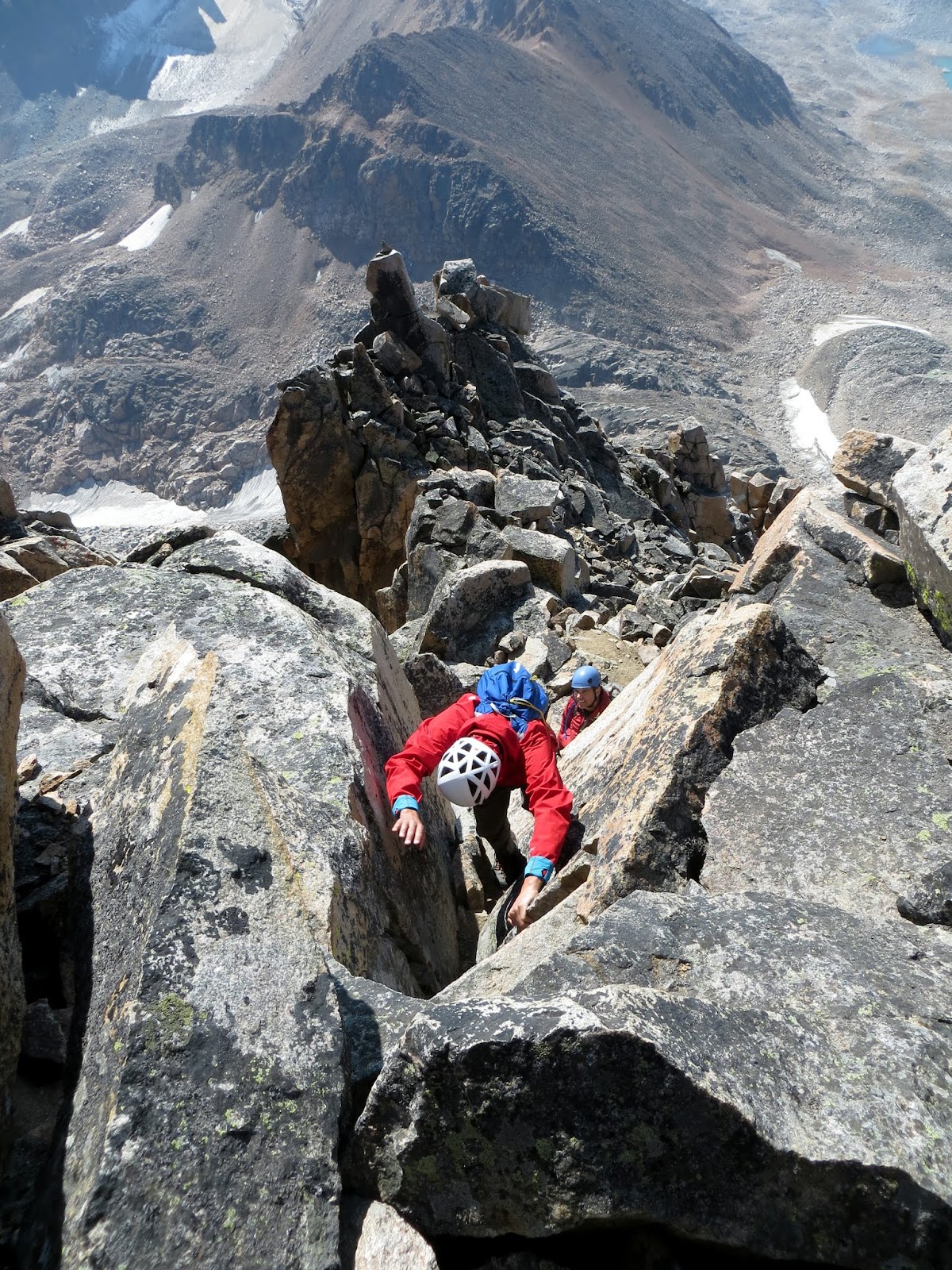
The couloir was
filled with loose rock as Dylan led us upward.
There was a fixed rope at the first steep portion, which could be
bypassed if needed. The majority of us
decided not to use this rope and climbed the good rock to the right.
 |
| Dave scrambling on the loose rock |
The next
steep portion had a bit of ice on it and also had a pair of ropes fixed to the rocks
above. This climb was a bit steeper and
trickier than the first one, and the ropes provided some security. Once past these two steep sections, we
carefully picked our way up through the loose rock, trying not to knock any
loose.
 |
| Michael figuring out the route |
 |
| Dylan |
 |
| Dan finishing off the second crux |
 |
| Dan moving up |
Eventually
we reached the end of the couloir at a ridge top and could look down into what
is known as “The Gash”. It was a big
drop on the other side of “The Gash”. We
traversed to climber’s left and picked our way upward, following the occasional
cairns. There were several ramps and steep
slots we used to move upward, but there wasn’t any exposure to speak of.
 |
| Michael |
 |
| All smiles |
 |
| Dan at "The Gash" |
Fifteen
minutes later all five of us were on the summit of Granite Peak – Montana’s
highest point! It had taken us 3.5 hours
to reach the summit from our camp. The sun was shining brightly, but the wind was
blowing, so we stayed on the summit long enough to sign the register and take
some photos. The ones that brought their
phones along checked the BSU/BYU football score (BSU lost) and updated their
Facebook profiles.
 |
| Summit! |
 |
| "Froze to Death Plateau" the other route to Granite |
Now it was
time to down climb the same route. We took
our time, being careful to get out of the way of any potential rockfall, as we
retraced our steps. The two crux points with
the fixed ropes required a bit of concentration, but we passed those without
any incidents. Upon reaching the base of
the slab, we all sat down and took a long break enjoying the scenery and out of the
wind. Whew! That hard part was done.
All that was
left was to boulder hop our way down the moraine and back to camp. Unfortunately, the boulder hopping was
sapping our strength. The hopping turned
into slogging, and everyone was lost in their own thoughts as we strung out. Everyone made it back to camp about four hours
after we had started our descent. Other
than Dave, we were a bit whipped.
 |
| Looking back up |
Dave, on the other hand, decided to climb the peak above our camp – Peak 11,379. With storm clouds gathering, we wished him luck as he took off.
While Dave was up "enjoying" another peak, the four of us sat around camp chatting while cooking dinner. Dave returned from his side trip right about the time the passing clouds decided to release some moisture. It wasn't bad, just enough to be an annoyance.
Dave also brought along a friend, a mountain goat which he kicked up on his ascent. "Little Dylan", as Dave called him, stuck around camp licking everyone's dried urine off the rocks surrounding camp. We had heard about this occurring, so were careful to relieve ourselves away from our tents. "Little Dylan" provided a couple hours of fun, with everyone taking goat selfies and coming up with urine marketing ideas.
 |
| "Little Dylan" |
 |
| View of Granite from camp |
It rained a bit more that night while we were all in our tents, but Monday morning was clear, though a bit chilly. After a quick breakfast we loaded up and headed out, reversing Saturday's 9 mile trek. Other than a close encounter with a black bear, it was an uneventful trip out.
We made it back in Cooke City at the tail end of the lunch rush, allowing us to enjoy our bacon cheeseburgers in peace.
An epic trip, with some epic guys!
Stats:
Mileage: Approximately 25 miles
Elevation: Approximately 4000 feet
Time: Who cares on a trip like this
Dan's Trip Report:
http://idahosummits.com/trip_reports/trip_report.php?trip_id=168
Dave's Trip Report: