
Since these peaks are all in the Lost River Range, we knew we were in for some serious scree.
As we crested the ridge and made it to the lake, we were greeted by a couple of barking dogs. Great. Three guys were tucked in their sleeping bags to get out of the now blowing wind, and greeted us with a "Welcome to Camp Wind," before calling off their dogs and covering back up.

We left Boise early Saturday morning and arrived at Long Lost Creek at about 10AM. We wasted no time in starting the hike up the trail.
We gradually gained altitude and after 4.5 miles and around 9000' feet we started up the steep slope to the saddle at 10,200'. The footing was great, especially when we found the sheep trail.
Once above the saddle it was a pretty straightforward climb up the ridge to the summit at 11,477 feet.


Though the ski line wasn't in, the views of Leatherman Peak from the trail did not disappoint. It didn't take us long to reach Merriam Lake at 9600'.
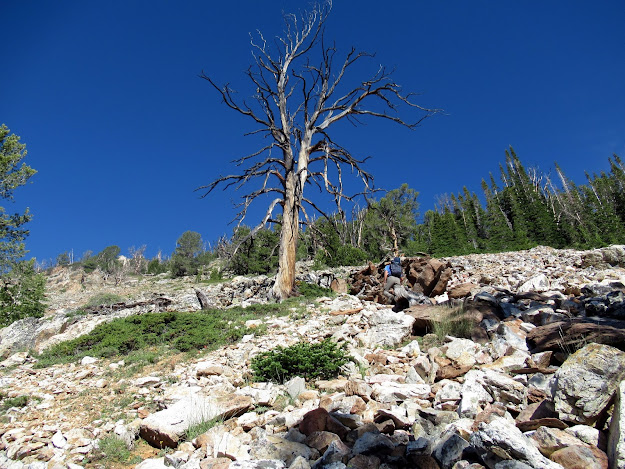
 |
| Castle Peak from the trail head |
NOAA had forecasted sunny skies and mid-70's and was spot on. The slight breeze made the hiking that much more enjoyable.
 |
| The Moat to the right of the saddle with Castle Peak |
Surprisingly, the trail continued past the turn off to Hell Canyon and Shadow Lakes. The bushwhacking was minimal the few times we lost it. Though it was almost mid July, the area was green and the wildflowers were blooming.
 |
| Peak 11,477, aka "The Moat" |
 |
| Michael cruising up the sheep trail to the saddle |
Once above the saddle it was a pretty straightforward climb up the ridge to the summit at 11,477 feet.
 |
| Looking down Long Lost Creek |


We took a break on top, eating some lunch and enjoying the spectacular views. Too bad the weather wasn't nicer.
Since we were planning on camping at the Leatherman trailhead that evening, we didn't dawdle for too long before starting down.
We re-traced our route on the descent but didn't lose sight of the trail this time and made good time back to the truck. A good warm up peak!
Stats:
Distance - 9 miles
Elevation - 3400 feet
Time - 7 hours car to car
Sunday July 12
After a great night's sleep on our cots, at the end of the West Fork Pahsimeroi road (the three campsites were taken), we were heading up the trail to Merriam Lake for our second peak of the trip, Sacagawea Peak. Another stellar day - no clouds, cool temps and a slight breeze.

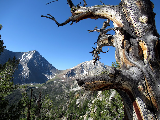
 |
| Mount Idaho towering over Merriam Lake |
We motored on past, continued around the lake a followed the inlet stream higher.
The difference on the East side of the Lost River Range is like night and day compared to the dryer West side. Streams, meadows, and wild flowers, were all in abundance.
 |
| Sacagawea to my right |
We followed the inlet stream as it turned right, up to the glacial moraine at 10,000' with Sacagawea staring us in the face.


Our goal was to obtain the ridge between Mt Idaho and Sacagawea but the ridge was guarded with either rock bands or cornices. Since we left our snow gear back as camp, we decided on the rock bands.
Our first choice was to our right, on the Sacagawea side of the ridge. It was steep and loose up to the rock bands. Once there, I figured we might be able to squeeze by the snow, but it was a no-go. The chute was filled with snow and the steep angle and poor snow quality caused us to turn back and find a different route.
 |
| Our failed ascent path |
So we re-traced our steps down and around to our left until we found another place that we thought would go. Again, it was step and loose, but we found a series of ledges through the rock bands. Then it was just a steep pull to the saddle at 11,000'.
| Michael finishing up the rock bands |
Once on the saddle, we had a view of our route to the summit. The gully looked like it was a long ways off and very steep. We were skeptical, but the clear skis have a way of tricking your eyes, so we dropped down to skirt the class 4 ridge and made our way to the gully.
As you can see from the picture below, the scree filled gully wasn't too steep. We picked our way through the rock, trying to find some that wouldn't slide.


We reached the 11,936 foot summit a little before 1PM, for a 5 hour ascent. Other than some wind, the weather was perfect.


After an extended break on the summit, we re-traced our route back to the saddle talking about how to get through the rock bands. Rather than follow our ascent we opted to stay to our right and luckily found a steep, loose (i.e. sketchy) chute that dropped us just where we wanted to be. Gotta like it when that works out!
As we made our way back through the green meadow area we came upon a herd of Bighorn sheep. There were close to 40 of them and they did not mind posing for a few pictures.


After spending way too much time with the sheep, we hiked past Merriam Lake and continued down the trail to camp.
We had some beta - "after a while leave the trail, bushwhack to the base of the mountain, climb, find a gully with stunted trees and get to the summit." This lack of detail made for a great adventure.
 |
| The summit is the left most point with the snow |


We had some lunch and perused the register, seeing names of old friends.

 |
| North Face of Mt Idaho |
After an extended break on the summit, we re-traced our route back to the saddle talking about how to get through the rock bands. Rather than follow our ascent we opted to stay to our right and luckily found a steep, loose (i.e. sketchy) chute that dropped us just where we wanted to be. Gotta like it when that works out!
 |
| Michael trying to not slide down the sketchy chute |
As we made our way back through the green meadow area we came upon a herd of Bighorn sheep. There were close to 40 of them and they did not mind posing for a few pictures.


 |
| Last look at Mt. Idaho |
Stats:
Distance - 8.9 miles
Elevation Gain - 4200 feet
Time - 10 hours car to car
Back at camp, I cooked up some In the Wild Chef Spaghetti Carbonara with Italian sausage. What a great way to finish off the day.
Monday July 13
Monday morning was a carbon copy of Sunday morning - clear, relatively cool and beautiful. We were both feeling a little fatigued, but nothing that some breakfast cake and coffee couldn't fix. Our goal for today was Merriam Lake Peak, aka Merriam's Pinnacle, aka, Peak 11,180.
 |
| Merriam's Pinnacle from Sunday morning |
We had some beta - "after a while leave the trail, bushwhack to the base of the mountain, climb, find a gully with stunted trees and get to the summit." This lack of detail made for a great adventure.
We weren't quite as energetic as the previous two days as we headed up the Pass Lake trail. After a while we decided to cut right and find the base of the peak. Luckily we found a nice elk trail that bypassed the majority of the deadfall.
Once at the base, we started up the very steep slope until we were blocked by the steep rock. We picked a narrow chute, and utilizing a couple of veggie belays, pulled our way.
After a bit, the slope opened up and we could almost see our summit. Or at least we thought we could.

I jumped up on the rotten ridge and started across. After 10 or so feet I needed to downclimb to get to the next section. At this point I wasn't feeling too confident. The rock was rotten, the exposure was big, and I was tired. I looked back at Michael and knew that this route was a no-go. So I carefully reversed course and we slowly downclimbed to where we could make a steep sidehill traverse.
Michael led the way across some extremely rotten, loose rock that at times was too close to the edge of some large cliffs. After the long traverse we headed up and arrived at the other side of the summit ridge. From here it was a walk up to the summit.
 |
| A portion of our route |
Once at the base, we started up the very steep slope until we were blocked by the steep rock. We picked a narrow chute, and utilizing a couple of veggie belays, pulled our way.
 |
| Michael enjoying the steepness with Leatherman in the background |
After a bit, the slope opened up and we could almost see our summit. Or at least we thought we could.


After reaching the main ridge we started sidehilling to bypass a large gendarme. Eventually we reached the "gully with the stunted trees." At least we thought we did.
 |
| Gully with stunted trees |
After carefully working our way up the gully, we reached the main ridge at roughly 11,114 feet, but couldn't see the actual summit. From our view of Merriam's Pinacle the day before, we knew that there were several summits, with the tallest being the farthest from our current position. Hmmm.
 |
| The summit's back there somewhere |
 |
| More sketchy sidehilling |
Michael led the way across some extremely rotten, loose rock that at times was too close to the edge of some large cliffs. After the long traverse we headed up and arrived at the other side of the summit ridge. From here it was a walk up to the summit.
 |
| Back side of the summit ridge we didn't take |
 |
| Summit shot |
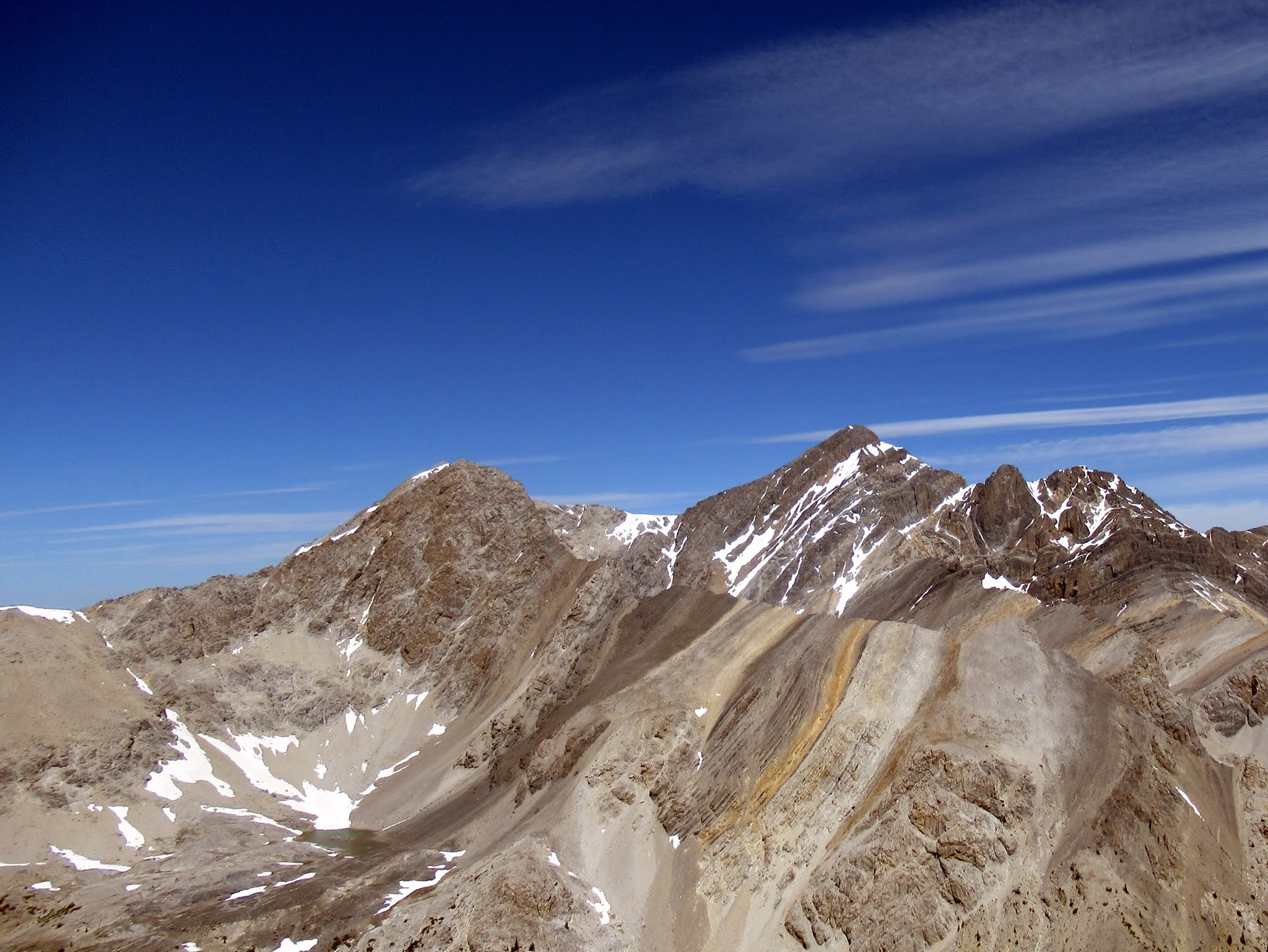 |
| Looking across the valley to Sacagawea with Mt. Borah in the background |
We searched around for the 1964 summit register that we had read about, but were unable to find it. Considering how few people climb this peak, we were a bit bummed. We had a nervous bite to eat before heading back down.
We carefully reversed our route and breathed a big sigh of relief once we were past the big sketchy sidehill traverse. From there it was just a knee busting descent back to the valley floor.

Unfortunately, we were not as lucky on missing the deadfall on the way out. We eventually wandered back into camp. I was one whipped puppy.
The statistics do not indicate the difficulty of this climb. It may have been the impact of the previous two days, but this was one exhausting (both physically and mentally) peak.
Stats:
Distance - 5.1 miles
Elevation - 3000 feet
Time - 8.5 hours
Another great multi-day outing with Mr. Pelton!


